Showing posts with label fox. Show all posts

Sunday, February 9, 2014

Isle Royale National Park | Day Seven

Huginnin Cove to Windigo / Washington Creek
(Map at bottom of post)

The sky over Huginnin Cove looked stormy when we got up at 7:30 am. We decided to skip breakfast since the hike back to Windigo was only about 4.5 miles along West Huginnin Cove Trail. We packed up quickly under the threatening sky and left at 8:30. We were sad to have to leave this wonderful place and would have loved to stay another day, but the weather continued to be consistent in its unpredictability, and we felt that heading back toward Windigo to be prepared in the event of more flight issues was the smarter thing to do. Anyone visiting the west end of Isle Royale should definitely visit Huginnin Cove; it's worth the short trip.

Stormy morning sky above Huginnin Cove
We departed the cove via West Huginnin Cove Trail, which heads south into the woods and is not nearly as interesting as its east counterpart. There are a few climbs and descents along this trail, as it traverses three different ridges. Like the east trail, WHCT eventually meets up with the Minong Ridge Trail, which leads back to Washington Creek Campground and Windigo. We were climbing a ridge near the intersection with the Minong, when Craig suddenly stopped in front of me and motioned for me to be quiet. A female moose and her two calves were slowly making their way through the brush a short distance in front of us, heading west along the side of the ridge we were climbing. We watched them through the thick brush, until they were mostly hidden in the woods off the trail to our right. Once we continued climbing the ridge, the cow moose heard us and then it was her turn to people-watch. We could barely make them out; the two small calves were hidden behind trees near their mother, who stood watching us intently. We continued on, happy to have finally seen our first moose of the trip.

Cow moose with 2 calves
We reached Windigo at 10:40 am and checked in with Ranger Valerie to see what the weather forecast had to say, and to see what the chances were of flying out today rather than tomorrow as planned. Neither of us really wanted to cut the trip short, but we also didn't want to push our luck given the weather and flying conditions of the last few days. It turned out that the plane was not flying, because no flights had been booked on this particular date. The decision was now out of our hands; we would stay another night at Washington Creek and attempt to leave tomorrow as originally planned. Whatever was going to happen would happen.

Someone at Windigo said that wolves were heard the night before by people camping at Washington Creek, which was exciting news. A fox trotted by us as we headed back down the path to the campground.
Inside Shelter #9 at Washington Creek
We settled in at Shelter #9, which had a good view of Washington Creek. It was cold and breezy; the sun tried to penetrate the clouds but was unsuccessful, and the heavy cloud cover remained all day. After making lunch, we watched ducks swim back and forth in the creek and then took a nap. Except for the occasional gust of wind or bird call, it was completely silent.

Around 6:00 pm, we took a walk to Washington Harbor. Earlier in the day at Windigo, we had seen a few park rangers looking like they were responding to something urgent. We now learned that a sailboat that was out in the harbor had started to sink – the Coast Guard at Rock Harbor was alerted, and the rangers we had seen at Windigo were heading out to help pump water from the boat and begin rescuing those on board. We would learn more details the following day from one of the stranded boaters. Peril on the high seas (lake)!

What is this fox doing?
On the way back to our shelter, we passed a small clearing just offshore, where a fox was having dinner. It had caught a bird and was sitting in the clearing eating it. It did not seem too concerned with our presence, and we watched it for a minute or so from around 10 feet away as it worked on its meal.

Oh, I have an audience.
Yes, I caught this bird. Now, if you'll excuse me...
Nom nom nom
It had been chilly all day, but the temperature dropped significantly as the sun went down. We went to bed at 8pm because it was too cold to do anything outside of a sleeping bag. Unfortunately, the weather forecast we had looked at earlier did not predict the temperature dropping to the mid-30s in the middle of the night. If we had known about this, we would have put our tent up inside the shelter to benefit from the retention of body heat. Instead, we hunkered down into our sleeping bags on the shelter floor, anticipating a chilly night in the 40s.

As we laid in our sleeping bags after dusk, the ever-elusive night-swimming moose returned to Washington Creek, splashing around in the dark just beyond our shelter. We wanted to see it, but neither of us wanted to get out of our sleeping bags and venture back into the cold to spy on it, so we attempted to get some sleep on our last night on Isle Royale. Maybe in the morning...

East and West Huginnin Cove Trail Marker


To be continued in Day 8: What will the weather bring?

Saturday, October 12, 2013

Isle Royale National Park 2013 | Day Three

Another Day at Siskiwit Bay


As predicted, it had been a cold night with the surf pounding loudly all night long. Despite my 15 degree sleeping bag, I slept with my puffy jacket on for extra warmth. I had set an alarm so that I would not miss the sunrise, but I was hesitant to venture out into the cold when it went off. I didn't want to regret missing it later though, so I hauled myself out of my sleeping bag at 6:45 am and walked down to the beach in the dark.

Sunrise at Siskiwit Bay

The bay was rough as the wind blew relentlessly from the open lake. I watched the sky lighten and change color while waves crashed on the beach. I had gotten up just in time; by 7:15 the show was over, and I headed back to the shelter to make coffee. I appeared to be the only person up and about.

View of the bay from the path to the individual tent sites

We spent our third day on Isle Royale relaxing and exploring more of the area around Siskiwit Bay. Though it was late in the season, a few types of berries and wildflowers could be found around our campsite. I had seen a few clumps of blueberries near the fire tower on the Feldtmann Ridge the day before, but there were none here that I found. The last time we were here in September, thimbleberries were plentiful, but not this time. While thimbleberry plants and raspberry bushes were scattered all over, the berries themselves were harder to find.


There are a few apple trees at the Siskiwit Bay campground, which was surprising to me. I learned later from speaking with Ranger Valerie that they were planted there sometime in the 1930s when the Civilian Conservation Corps had a camp in that area. Apple trees can be found in a few other spots on Isle Royale where the CCC also had camps. Daisy Farm was one location, and there were one or two others that I can't remember now. We ate a couple of these small apples for the sake of doing it, but they were extremely tart. 
Apple tree at the start of the path to the individual tent sites
I investigated the individual tent sites, which I had not seen the day before. Site #1 is great. It has a view of the bay, a picnic table, and a flat, shaded spot for a tent. This would be a really nice place to camp, and although I felt lucky to have scored a shelter the day before, I would have liked to pitch my tent here. Sites #2 and #3 were a bit further into the woods and away from the water, but also nice. They were both secluded, spacious and had good tent pads. On the other side of sites #4 and #5, which are the two shelters, site #6 is much further back in the woods and not as appealing as the others. The tent sites were all deserted early in the day, as everyone who had camped here the night before had moved on. 
View of the bay from tent site #1
Inside shelter #5
It was sunny for most of the day, but it remained windy and did not warm up much. The fox returned when we were getting ready to make dinner. An interesting animal and obviously a professional thief, it seemed to never stop moving. It didn't approach us or linger; it trotted through camp, efficiently assessing the situation to determine if anything could be easily pinched while seeming aloof at the same time. It was as if we were not even there. Later that afternoon, some hikers down by the fire ring reported that it came up to the picnic table while they were sitting there, looked all around them for food, but ignored them the whole time.

A fox trots through camp

The wolf that came through camp the night before did not make a repeat appearance. We walked along the beach at the end of the bay again in the evening to look for new interesting animal tracks, but didn't find any. The sky had become overcast earlier in the evening, and we learned from some fellow hikers that it was supposed to rain the following day. Without any stars to gaze at due to the cloud cover, we turned in early, wondering what the next day would bring.

To be continued in: Day 4 - Siskiwit Bay to...? 

Sunday, October 6, 2013

Isle Royale National Park 2013 | Day Two


Feldtmann Lake to Siskiwit Bay
(Map at bottom of post)

Siskiwit Bay
Thunder and heavy rain woke us up at 5:30 a.m. By 7:00, the rain had stopped, and loons were calling across Feldtmann Lake. Not wanting to get up, we laid in the tent listening to our surroundings for about an hour. We made oatmeal and coffee for breakfast before packing up and hitting the trail at 9:30. We were disappointed to leave Feldtmann Lake without having seen a moose, but we still had 7 days ahead of us and a lot to look forward to.

Hiking on the Feldtmann Ridge
The Feldtmann Ridge Trail parallels the south side of Feldtmann Lake for about 1 ½ miles before arriving at the base of the Feldtmann Ridge. A steep climb that ascends about 240 feet leads to the top of the ridge and views of Feldtmann Lake from above. After the sweaty climb, breaking out on top of the ridge was welcome. It was overcast and windy, and the cool air felt wonderful. Hiking on top of the ridge is very pleasant, with knee-high yellow grass surrounding the exposed red conglomerate rock that the trail – and the ridge itself – is made of. It is interesting that this part of the island's rock is red, while the Greenstone Ridge and other areas to the north and east are grey. The openness of the ridge is a nice change from the woods and the thick, high vegetation encountered on much of this stretch.

The Feldtmann Ridge Trail enters a white birch forest
The trail does not remain out in the open along the entire ridge. It weaves in and out of the woods, at one point crossing a stream, as it slowly ascends to a fire lookout tower. The tower stands on top of the ridge approximately halfway between Feldtmann Lake and Siskiwit Bay, and it's where we stopped for lunch around 12:30.

Approaching the fire tower on the Feldtmann Ridge
I climbed up the tower steps as far as I could go before the structure is closed off near the top. From here, Feldtmann Lake can be viewed to the west, Lake Halloran and Siskiwit Bay to the east, and the Greenstone Ridge to the north.

Looking west from the fire tower on the Feldtmann Ridge
After resting and eating peanut butter and jelly tortillas, we resumed hiking. The trail leaves the open ridge just east of the fire tower and re-enters the woods. For much of the way from here to Siskiwit Bay, the trail passes through thick, high brush. Some of this section of trail had been a logging road in the 1930s and is now grown over. I love Isle Royale, but in the interest of truthful trip reporting, I do not want to overly romanticize the experience: this part of the trail kind of sucks. The vegetation is so thick that I could not see Craig hiking in front of me for much of the way, nor could I see the actual path below my feet at times. Although there is no easy way to get turned around, from time to time I wondered if we were on the right path. Branches scraped at our arms, and colorful, furry caterpillars hitched rides wherever they could latch onto us (actually, I liked that part). This stretch is tiring, not because the terrain is rough (it is actually pretty flat), but because it is long and tedious, with virtually no scenery to enjoy. 

Moose and wolf scat on the Feldtmann Ridge Trail

We reached Siskiwit Bay at 3:30 p.m. The campground here offers 2 shelters, 4 individual tent sites, and 3 group tent sites. The shelter at site #5 was open, and we collapsed into it gratefully. I changed out of my hiking boots and into Crocs and didn't move for about a half-hour. Shelter #5 has a view of the bay and the standard picnic table out front. The day had become sunny and beautiful, and we were happy to be spending the next 2 nights here. Suddenly, trekking through all of that brush felt worth it.
Siskiwit Bay

Since our tent had been packed away wet after the morning's thunderstorm, I laid it out to dry in the sun, and we walked down the path to the bay to check things out and collect water. The path from the shelter curves through tall yellow grass before descending to the shore, where a community fire ring and a couple of picnic tables make a nice gathering area next to the dock. The beach here consists of smooth red stones and pebbles, and a breakwater made of boulders shields the dock from rough water. It is very quiet here, and I looked forward to waking up early the next morning to watch the sun rise over the east-facing bay. 

From the dock at Siskiwit Bay. The fire ring and picnic tables are on the shore between the dock and breakwater. Shelter #5 is at the top of the grassy hill at the edge of the woods.
The water was cold, but not so cold that we couldn't get in, and we both spent some time cooling off in the bay before returning to the shelter to make dinner. We used the twig-burning stove, which was challenging since most of the twigs we found were wet from the morning rain. After a few false starts and a bit of smoke, we had a small cooking fire burning in the little contained stove. Because twigs burn away so quickly, this type of stove needs constant feeding and supervision in order to prevent the fire from burning out and having to start over. Before long we were happily eating cheesy noodle casserole at the picnic table. A fox trotted by while we were cleaning up, looking around briefly for anything interesting to steal before moving on and disappearing in the tall grass.

Dinner prep
After dinner, Craig walked down to the group fire ring to dispose of the stove's ashes. By now, people had started to gather there to talk and absorb the sun. While Craig talked to fellow hikers down by the water, I read a book at the picnic table and had my camera on-hand in case the fox came back through camp. 

And then this happened: 
Left: Hanging out at the shelter picnic table.   Right: An unexpected visitor.
I saw movement and looked up to see an animal walk across the path and disappear into the grass. I stared dumbly for a few seconds, not believing what I was seeing, before picking up my camera. It wasn't the fox returning for a visit; it was a wolf. It turned around and emerged onto the path leading up to our shelter, around 30 feet away. I looked beyond the path to where Craig was talking with other hikers at the fire ring. No one but me could see what was happening because of the tall grass. The wolf looked from side to side, then started walking up the path toward me. 

I stood up, thinking that it might not realize I was there. It seemed focused on the grass in its immediate vicinity, and it kept walking toward me. This was really exciting, but how close should I let it get? I knew it was wrong, but part of me wanted to just stay quiet and see what happened. The more sane part of me knew that would be inappropriate for a number of reasons. It took a few more steps closer, then I clapped my hands and yelled at it like I was scolding my dog for being on the couch. It sounded stupid to me, and the wolf was not very impressed either. It stopped walking and looked at me for a second or two, but it seemed unconcerned. Then it turned around and slowly walked away, turning left where the path forks off and leads back toward the main hiking trails. 


Not wanting it to leave altogether before Craig had a chance to see it, I walked down the path and waved my arms to get his attention, while trying to keep track of the wolf's whereabouts. After a few frustrating minutes of Craig not understanding why I was waving frantically and not saying anything, he realized that there must be something to see and everyone walked up to meet me. The wolf was standing on the path a short distance away, it's coloring allowing it to blend into the grass nearly perfectly. We watched it as it looked around, observed us watching it, then turned and walked away for good. I took a video of it during this time, but the quality is very bad.

Wolf track on the beach at Siskiwit Bay
At dusk, Craig and I walked to the trail junction where the Island Mine Trail begins. We followed the trail to where it leads out onto the beach at the end of the bay. This is known to be a good place to spot animal tracks, especially in the early morning. We thought this may have been the direction in which the wolf had traveled, and we were right. Its tracks were clearly visible down the length of the beach. We walked along the beach for a while and returned to camp as it was getting dark. 

Back at the dock, we watched river otters swimming near shore. The couple we had flown with were camping here also, and they joined us at a picnic table where we traded hiking stories. Suddenly the fox appeared, and we watched its silhouette in the dark as it trotted around us for a few seconds before disappearing once again. Billions of stars shone in the black, moonless sky. It was going to be a cold night.

Day 2 route
 To be continued in: Day 3 - Siskiwit Bay Part Two (no hiking day)

Sunday, September 29, 2013

Isle Royale National Park 2013 | Day One

Windigo to Feldtmann Lake
(Map at bottom of post)

Feldtmann Lake
After debating what route(s) to take this time – Hike the Greenstone Ridge from one end of the island to the other? Explore the west side of the island, which we hadn't seen before? Return to the island's east side, but hike to places that we didn't get to last time? – we decided to visit Isle Royale's western end. We opted to travel by sea plane this time, and we booked an 8:00 am flight to ensure an early arrival at Windigo and plenty of time for hiking the first day. 

A freighter on Lake Superior
Our plan was to hike the Feldtmann Ridge/Island Mine loop, working in a stop at South Lake Desor. Once back at Windigo, we would then hike the short Huginnin Cove loop, spending a night on the island's north coast. We had eight days; this was a lot of time for what we were planning, and it ensured we would have an extra day or two to spend in places we really liked. We planned to spend two nights at Siskiwit Bay, and maybe an extra night at Huginnin Cove depending on how everything went. Anything could happen once we were there, so we were open to winging it a little. 

Feldtmann Lake viewed from the sea plane
In addition to fewer people and fewer bugs, going after Labor Day also allows visitors to stay extra nights in places that have stricter limitations during peak season. On the flip-side of that coin, however, going late in the season also means the camp store is either low on supplies or closed for the season altogether. Visitors must arrive prepared with everything they will need; relying on the camp store to have essential items is not advised.


8 days' worth of food for 2 people. The squeeze tubes were eventually filled with peanut butter and jelly.

Because we took the sea plane, we were not able to bring fuel with us for our camp stove. This made for some strategic planning when it came to food. We brought an Emberlit twig-burning stove (given the restricted nature of campfires on the island, we confirmed pre-trip that these are ok to use) and a tiny Snow Peak isobutane stove with us, as well as several meals that could be made with cold water. The camp store at Windigo would be open the day we arrived, but it was closing right after. If it had fuel left, we would buy it for the Snow Peak. If not, we would make do without. In addition to the fuel situation, we brought a little extra food with us in the event we were unable to leave on our scheduled departure day. The sea plane does not fly in dangerous weather – especially fog – and Lake Superior's weather is famously unpredictable. 
 

Flying over Isle Royale's western end

We arrived at the Houghton County Airport by 7:30 am. It was dark, and we were the only people there. We hung out in the Royale Air Service waiting area until the pilot appeared and led us outside to the small plane. In addition to the pilot, the sea plane seats four passengers, and another couple from the Metro Detroit area of Michigan soon joined us as we got ready for departure. On busy days, the pilot flies back and forth to the island all day, picking up and dropping off at both Windigo and Rock Harbor. Because of this tight schedule, there is not much room for tardiness, and we left promptly at 8:00. The weather was questionable; it was starting out overcast with a high probability of rain and thunderstorms later on. I had checked the weather outlook before leaving home, which was absolutely pointless, but it made me feel better to see that the week was supposed to be partly cloudy with barely any rain predicted. This was, of course, completely subject to change. 
 

Coming in for a landing in Washington Harbor

The flight lasted around 30 minutes, and it was smooth sailing over Lake Superior. Approaching Isle Royale and flying over forest, bays, and inland lakes was exciting, as was the fast descent and landing in Washington Harbor. The pilot maneuvered us to the sea plane dock, where Ranger Valerie was waiting to greet us. Before leaving, Craig asked the pilot about the likelihood of being stranded due to weather. He responded that it was definitely possible since things tend to get exciting in September weather-wise. He told us that if we got back ahead of schedule and wanted to leave early in the event bad weather was coming, we should hang out by the dock and come talk to him when he flies in. If he could get us on the plane early, he would. This seemed ominous and hopeful at the same time.


We walked a short path up a hill to the Windigo visitor center, where Ranger Valerie registered our itineraries and talked to us about the island and good practices for our visit. We learned that there are currently around 975 moose on the island, and the current wolf count is eight. This is depressing, but in addition to the eight confirmed wolves, the small pack that lives near Siskiwit Bay is believed to have recently had two pups. Because of this, there is a lot of communication going on amongst the members, which means that their howls are being heard often. Ranger Valerie confirmed that rain was guaranteed in the forecast, and she cautioned about slippery conditions on the trail, especially on the protective boardwalks. I had forgotten how slippery these foot bridges can be, and we would likely encounter many of them due to the swampy nature of the island's southwest corner. 

Inside Windigo Visitor's Center
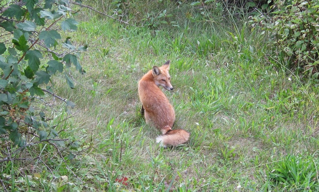
After orientation, we walked a little further up the hill to the camp store. On the way there, a fox trotted out of the brush and onto the path to observe the newcomers. After a few seconds, it returned to the woods uninterested. The store had one small canister of fuel left, which we bought. There were also a couple of very large canisters of fuel on the shelf, and various food and snack items that would seem like heaven at the end of a trip, but were not necessary at that moment. 
 

The Feldtmann Lake Trail follows Washington Harbor for about a mile

At 9:30 am, we began hiking the Feldtmann Lake Trail. The sky remained overcast, and the temperature felt like somewhere in the mid-70s. The trail runs along Washington Harbor for about a mile, then it turns inland and climbs a ridge. Once at the top, the trail breaks out of the woods, offering a view of Grace Harbor and Lake Superior to the west, and providing a nice place for a break after the steep climb. The trail leaves this ridge and re-enters the forest. From here to Feldtmann lake there is not much in the way of views. There is a lot of thick vegetation on this part of the island, much of it shoulder height or taller, and it can be tedious to hike through. On the bright side, the hiking is fairly easy. At one point I spotted a moose track in the mud, but we saw no moose on the trail. The area was thick with thimbleberry plants, but few berries. Around 12:30 we stopped for lunch and ate peanut butter and jelly on tortillas with a solo hiker we had met who is also from Metro Detroit. 
 

View to the west

We arrived at Feldtmann Lake at 2:15 pm. This area is known for being a good place to see moose, and my hopes were high. The trail runs right along the lake through the campground, with all but one campsite located across the path from the lake. Site #2 is right on the lakeshore and is a really nice spot. This site was already occupied, so we chose #4, which had a view of the lake and good water access. Feldtmann Lake is tent only; there are no shelters here. Each of the sites has its own section of lakefront, and although it was still overcast, the lake was pretty, with the surrounding trees mirrored on its surface, and views at the far end of the Feldtmann Ridge.


Looking through clear water at the rocky bottom of Feldtmann Lake

We set up our tent and spent some time wading in the lake. The narrow beach is made up of red sand and tiny red pebbles, eroded versions of the rocks on the lake's bottom and the red rock we had been seeing all day during our hike. A few garter snakes were hanging out among the roots of a tree on our path to the water, and they slithered into hiding every time we walked by. I had been walking around in knee-deep water for a little while, when I looked up to discover a great blue heron casing the beach about 20 feet away. I watched it walk quietly into the lake, looking intently for fishing prospects. It walked around for about 10 minutes before unfolding its huge wings, taking flight, and gliding just over the lake's surface. It relocated further down the beach, where tall grass near the shore must have looked like a more promising location.


Great Blue Heron in Feldtmann Lake

I returned to our campsite for dinner, which consisted of the heaviest things in our food bag that we wanted to get rid of first – a foil pouch of salmon for Craig, and tuna for me, which I ate on a tortilla with mayo. Another thing that makes Isle Royale unique is its lack of bears. Typically, we would refrain from bringing such interesting-smelling food with us on a
Section of trail lined with red stones
backpacking trip simply to eliminate any unnecessary attraction to our stash. Without that concern, there is a little more freedom to bring food we might otherwise leave at home. Campers at Isle Royale are actually advised to keep their food in their tents, a practice so inherently wrong to most northwoods hikers that it can be hard to get used to. The biggest threats to a hiker's food on Isle Royale are the red fox and the red squirrel, a smaller version of the mainland squirrel and a subspecies unique to the island.


As soon as we finished eating and got everything put away it started raining. We passed the time by napping in the tent. The rain did not last long, but the sky never cleared, and it started getting dark early without the sun. A spur trail from Feldtmann Lake leads to Rainbow Cove about ¾ of a mile away. Facing west across Lake Superior, this is known to be an excellent place to watch the sunset, and I was looking forward to walking there later in the evening. Unfortunately, a visible sunset was not on the horizon that night, so we spent more time on the beach of Feldtmann Lake before turning in at 9:00. We didn't see any moose. I read for a while and listened to fish jumping in the lake before drifting off to sleep.

Campsite #4 at Feldtmann Lake
Day One Route

To be continued in: Day 2 - Feldtmann Lake to Siskiwit Bay