Continued from: Day 2
 |
| Tobin Harbor, at the dock near Hidden Lake |
(This report is regarding day hiking out of Rock Harbor. For backpacking trip reports, go here for the eastern, Rock Harbor side and here for the western, Windigo side.)
Map at the end...
Nemesis: a long-standing rival; an archenemy.
Map at the end...
Nemesis: a long-standing rival; an archenemy.
Sometimes people make decisions they know they will regret. They could opt to make different choices, but intead they forge ahead, knowing they’re going to hate themselves later on. Welcome to Day Three.
I woke up with a sinking feeling that today wasn’t going to be awesome. It had rained overnight, and I woke periodically to the sound of a mild storm roaming through Tobin Harbor. I hoped that it would stop by morning since I had planned an 8:00 am water taxi to Hidden Lake dock, followed by a 10 ½ mile hike, much of it on the Greenstone Ridge. This would check off Goal #2 of the trip: Hike to Lookout Louise to take in the views from its elevated vantage point. I was really looking forward to that, but when I got up and looked out the window, I found my nemesis smirking back at me: Fog.
 |
| The spellbinding view from my window this morning. Fog is capitalized throughout this post out of respect for a worthy adversary. |
Fog and I have a complicated relationship. I love the bewitching bastard and the spell it can cast over the world. Fog can turn a mundane scene into something magical, but its moodiness sometimes turns malicious. Fog has been known to show up when I’m spending time with other friends (you know...the sun, sky, and various other things that are more fun when visible) and specifically did not invite it. Fog sometimes meddles in my life, blocking trailside views of picturesque cliffs, and sadistically snatching away majestic vistas at the end of cold, wet, grueling hikes up mountains, leaving me soggy and disappointed. I was not expecting to see Fog today, but I suppose I should’ve been more vigilant on my way here...maybe doubled back a few times before crossing the Mackinac Bridge to make it look like I was going to Sleeping Bear Dunes. Maybe checked behind the seaplane a few times to make sure I wasn’t being followed by any suspicious-looking clouds. This was exactly the type of opportunity Fog would be waiting for.

I sat down and thought about the day. I had paid $58 for the water taxi, which runs rain or shine, unless the conditions on the water are unsafe. It had stopped raining, but it was very dreary outside, with a chance the rain might return. Regardless, the brush out on the trail was going to be soaking wet after being rained on all night. Hiking in the rain is a reality of backpacking; you have to get from one place to the next despite the weather, so you have to just suck it up. But did I really want to spend the day hiking in those conditions on purpose, when I didn’t have to? I was on vacation after all, and as a grown-up, I could do whatever I wanted.
I looked out at the harbor and the deceptively enchanting fog-ensconced trees on the other side, then at my semi-comfortable bed and fully-stocked kitchenette. Staying in for the morning, reading, and eating warm foods sounded really attractive, $58 loss be damned. But this hike is what I had planned to do today, and as much as I didn’t want to hike all day in miserable weather, I also didn’t want to regret not doing it later. I sighed, came to terms with the fact that I was probably making a stupid decision, and proceeded to get dressed and fill my backpack with everything I would need for a long, probably shitty, definitely wet, hike. Maybe I would get lucky and find that the taxi was cancelled due to distant lightning and then I would be off the hook and guilt-free.
 |
| The Sandy and a couple of water taxis wait in the Fog |
 |
| Let the good times roll |
 |
| A couple of barely discernible old cabins on islets in Tobin Harbor. Taking photos from a moving boat in the fog is hard. |
I was dropped off at the dock near Hidden Lake, and I watched the Julie Leigh disappear into the fog on her way to pick up a few campers in Duncan Bay to the north. Once the boat was out of earshot, complete silence enveloped me aside from the occasional birdcall. (For a short video of this scene, go here.) The scene of Tobin Harbor from this dock was wonderfully mystical because of the Fog. I had a hard time leaving that spot, especially given how much I wasn’t looking forward to hiking by this point. It was a slightly chilly morning, but I knew I was going to get too warm to keep my rain jacket on while hiking, so I stowed it in my backpack and reluctantly set out on the trail. It was 8:30.
 |
| The water taxi leaving me at the Hidden Lake dock |
Lookout
Louise is a viewpoint that sits just above the very eastern-most end
of the Greenstone Ridge and provides an outstanding view of the
ridges, bays, and islets of the Five Fingers area. The Greenstone
Ridge Trail actually begins here, but because of its remote location,
nearly all hikers who do the cross-island Greenstone Ridge hike from
Rock Harbor to Windigo do not access the trail at its true starting
point (or finish there if hiking in the opposite direction). The
only reasonable way to incorporate this section (without hiking a
ridiculous distance, then having to backtrack) is to access it by
boat, which most hikers aren’t going to do because of logistical
complications. Instead, the Greenstone is typically accessed at its
junction with Mt. Franklin Trail, the earliest it can be reached on
foot from Rock Harbor. This means that the eastern end of the
Greenstone Ridge Trail—approximately 5 miles of it—between Mt.
Franklin and Lookout Louise is hiked far less than the rest of the
trail. (And I saw no one during my hike of this entire stretch.)
Of
Lookout Louise, Jim DuFresne’s essential Isle
Royale guidebook says, “the lookout spot provides the most
spectacular view in the park, but most of the 1.0-mile trail is a
straight, uphill climb.” (Isle
Royale National Park: Foot Trails & Water Routes)
The trail starts at the dock, follows along Tobin Harbor and
crosses a wooden bridge over the outlet of Hidden Lake before curving
around the western side of the small lake, then beginning its climb.
I stopped around the middle of the bridge to apply insect repellant,
as mosquitoes were an immediate issue in the wet environment. I was
happy to find an outhouse near the curve of the trail, which I took
advantage of. On a day like this, even the small wins deserve
mentioning.
 |
| Hidden Lake |
Lookout Louise Trail looked primordial, intensified after the rainfall. Enormous boulders rest along the trail and loom overhead; however, Fog obscured the view of Monument Rock—a towering 700-foot sea stack left over from an ancient, much higher lakeshore that predated Lake Superior. I saw no sign of this giant monolith that looms high above the trail around the halfway point. Fog had it completely concealed.

Scenes from Lookout Louise Trail

I had looked forward to seeing Lookout Louise for years, and had planned on lingering here to take photos and spend time just enjoying the view, which I would have all to myself since I was the only person for miles around. I passed the signpost marking the beginning of the Greenstone Ridge Trail and knew the lookout was only 1/10 mile ahead. I continued climbing until I reached the small rocky outcrop at the top. The area was fairly overgrown with trees, so it wasn’t obvious to me right away that I had reached the end, and I looked around to make sure I wasn’t missing a spur or side trail to confirm that I was as high up as I could get. I looked northwest, past the edge of the cliff, toward Duncan Bay and its surrounding long peninsulas, to Five Finger Bay beyond that, and further still across the northern expanse of Lake Superior to the distant Canadian shoreline. This is what I saw:
 |
| Well played, Fog. |
I tried not to be bummed out. After all, I’d only been waiting for this since 2009. I stayed exactly the amount of time it took to snap the above photo, then turned away from this "most spectacular view in the park" and headed back down the trail.
Trip Goal #2: Attained, technically. Now to hike back.
 |
| Trail marker at the beginning of the Greenstone Ridge Trail near Lookout Louise |
DuFresne describes the first leg of my hike thusly: “The east end of the Greenstone rewards backpackers with some of the best views from the entire trail...[The trail] quickly becomes one of the most pleasant walks on the island. Most of the hike is level and easy and passes through extensive thimbleberry patches...” I had very much looked forward to this hike, but today’s conditions were less than ideal. As mentioned, the eastern 5 miles of the Greenstone Ridge Trail are not heavily traveled. This means that the footpath, while ambiguous at times across its entire length, is even less obvious in this section due to the lack of constant foot traffic that the rest of the trail sees all season long. I set out knowing this and was not bothered; however, the rain that had fallen overnight obscured the trail even further, weighing down the brush and causing much of the visible pathway to be hidden underneath.
 |
| Greenstone Ridge...looking for cairns |
At first this wasn’t too much of an issue. Walking high on a ridge, it’s at least obvious where not to go—veer too far left or right, and you will eventually find yourself tumbling down a slope. The trail alternated between traveling through forest, then breaking out into open grassy areas that provide awesome views to the north and south of the island on clear days. There was no view whatsoever today, but some of these spots looked pretty magical in the Fog. Lookout Louise aside, I found that I wasn’t so disappointed by the lack of views on top of the ridge. What I didn’t like, however, was how soaking wet I was getting.
I had kept my rain pants on in order to keep my lower half dry while hiking in wet brush. In order to avoid overheating, I left my rain jacket in my pack, and the further along the trail I went, the denser and taller the wet brush became. I stopped early on because I thought it would be a good idea for future story-telling to take a photo looking down at my legs to show my rain pants and boots getting wet. Hey, look how wet I got, ha-ha! At least I was prepared! Later that day I would look back and realize that I hadn’t even understood the meaning of the word “wet” at that point in my life. If only I’d taken that photo a few hours later, but eventually I had to put my camera completely away in a ziplock in my pack because I could no longer keep it protected from water. Later, when I eventually emerged from this soggy hellscape and reached a point where I could rest and change shirts, I had lost interest in photographing anything, and had no desire to ever tell anyone about this hike.
 |
| Greenstone Ridge Trail |
Before long, I was getting soaked well above the waist by various dense plants and trees as I struggled to stay on the path, which was becoming increasingly difficult to follow. Thankfully the terrain was mostly flat, but the “pleasant” and “easy” walk described by DuFresne was neither of those things on this day. I stopped often to take stock of my situation, looking around whenever I was no longer confident that I was following an actual path. This happened constantly for a few miles, significantly slowing my progress. Much of the time I did not see any sign of the trail, and I plodded forward on some kind of instinct I didn’t know I had. At one point I realized I had veered off-course, but as I looked around, I had no idea where the trail was. As I backtracked, I happened to look down at just the right moment and spotted a small cairn, maybe 6” tall, almost completely hidden in wet, drooping brush. I repeatedly told myself that I couldn’t get truly lost at the top of the ridge. If worse came to worst and I completely lost the trail, I could always turn around—I had managed to stumble blindly this far, I could find my way back the way I had come and return to the dock. Eventually another boat would show up there. Maybe not today, but surely the next? It would be uncomfortable and embarrassing, but I probably wouldn’t die waiting to be found there and begging a ride back to Rock Harbor.
 |
| Left: Now you see the trail. Right: Now you don't. Even in short grass, the trail tended to disappear. |
Adding to the ambiance, mosquitoes gleefully reveled in my presence, coming from miles around for the chance to feast on the only warm-blooded creature in the vicinity. Insect repellant only works so well when it is continually wiped away by wet leaves. While I didn’t see any moose, all along the grassy parts of the trail I found obvious signs of their sleeping forms in large, round depressions in the wet grass. These depressions were everywhere, to an unnerving degree, making me feel surrounded though I surprisingly saw no animals other than a single snowshoe hare on Lookout Louise Trail. This again made me think about the rising number of moose on Isle Royale due to the decline of its wolves. If the NPS does not opt to bring new wolves here, the moose are going to decimate the island and start dying of starvation.
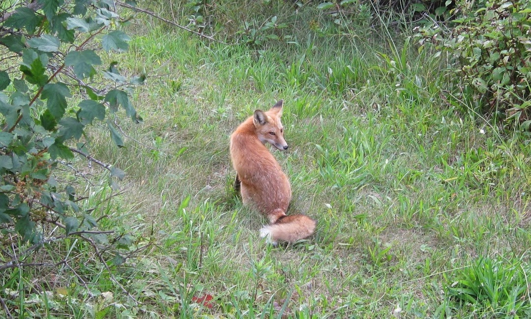
In a few spots on the bare rock of the Greenstone Ridge, I saw scat that at first glance looked like wolf, but was likely from a fox. I wanted to believe that there were a few secret, deep-cover wolves still out there, roaming nearby but unseen in the Fog, perhaps acting as my spirit guides and preventing me from going too far astray. But sometimes a turd is just a turd.
 |
| A metaphor for this hike |
At some point I began singing songs to myself to pass the time and keep myself sane, as counter-intuitive as that may sound. As time wore on, the reassuring idea of backtracking to the dock became less comforting as the distance behind me grew and grew. Just when I completely lost confidence that I was still on the trail, a path suddenly cut across the grass, and a signpost appeared that simply said, “P.” Yes! I was at a junction with a canoe portage trail. This could only mean that I was going the right way and was somehow still on the trail. I had never been so happy to see a trail marker. My spirits lifted a bit, but before long the path disappeared once again, and I found myself in the same predicament.
 |
| Left: The photo I took earlier on. Notice the mosquito photo bomb. Right: The portage trail sign that temporarily saved my sanity. |
On I trudged. To add insult to injury, some of the “extensive thimbleberry patches” mentioned above had grown to over 6 feet tall and towered over my head. At other times, this can be a fun experience. Thimbleberry leaves can grow to the size of dinner plates, and the berries themselves are delicious. Knowing how expensive anything made with thimbleberries is, being in a position to pick and eat as many of them as you want along the trail is a wonderful thing. Today, however, the plants dripped water on my head and stuck wetly to my arms and torso as I pushed my way through them, much of the time not even knowing if I was going the right way. And the shittiest part? The berries weren’t ripe yet. Later, at some high point on the ridge, I noticed a few berries that were juuuuust starting to show the slightest hint of color, maybe due to their extra-sunny (under better circumstances) vantage point. Purely out of spite, I ate one of them. It was awful. As expected.
All of a sudden I found myself on terrain that looked a bit more familiar and far less wet. I looked to my left and realized that I could see some of the landscape off to the south. No sooner had I thought, “I know this place,” then I found myself looking at the signpost at the junction of The Greenstone Ridge, Mt. Franklin, and Lane Cove Trails. I had made it out! Just up ahead a short distance would be Mount Franklin—a rocky outcrop 1,080 feet high that provides a wonderful view north of a huge expanse of forest, followed by bays, peninsulas, Lake Superior, and Canada. Even if Fog ruined the view, it would still be a good spot to stop for a break. I hoped that it wasn’t overrun with people so that I could take some time to rest, change into a dry shirt, and eat lunch. It was around 12:15—it had taken me almost 4 hours to hike 5.8 miles.
 |
| Mount Franklin |
I arrived at Mount Franklin to find only 2 hikers there, who were hoisting their packs after having finished up a break. Aside from the boat driver, these were the first people I had seen today. They were 2 young, college-aged men, and one of them was so excited to be on Isle Royale that he could barely contain himself. It was adorable. We exchanged greetings, and the excited kid said it was his first time here, and he asked me if I’d been here before. When I told him it was my third time, he gushed with questions. Did I take the Ranger III? (The plane?! What’s that like?) Had I seen any moose? Where was I hiking from? I was very aware that I looked like I had just washed ashore after fighting for my life at sea for 8 or 9 days. I told him about my morning, explaining the water taxi, Lookout Louise, the trail conditions, and the menacing thimbleberries. When I mentioned the mosquitoes being especially bad, he asked me if I needed insect repellant—as if this was my first rodeo.
He told me about their trip so far and that they had just come from Lane Cove. (His friend clearly wanted to get going, but looked to be waiting as patiently as he could.) I enjoyed his story and could relate; on my first trip, we did the same thing—hiked from Rock Harbor to Lane Cove on our first day, and I remember exactly how I felt. The decent off the Greenstone on Lane Cove Trail is extremely steep and challenging, but camping at Lane Cove is wonderful. Of course, then there’s the climb back up that trail. The kid said that after they experienced the descent on Lane Cove Trail, they found the idea of climbing back up it to be so daunting that they decided to stay there for two nights to put off doing it. I found this hilarious and his pure honesty retelling the experience was endearing. They had just climbed back up Lane Cove Trail and recuperated at Mount Franklin. He told me where they planned to go over the next few days, and he kept referring to Chickenbone Lake as “Chicken Wing” and his friend kept correcting him. They planned to camp at East Chickenbone Lake campground, which is known to be a dud (or absolute dunghole, some would argue), and I advised switching to the West Chickenbone campground if at all possible with their route. He thanked me as they headed down the trail, and I felt like a wise old sage. I wonder how the rest of their trip went.
 |
| View from Mount Franklin. On a clear day, Canada is seen in the distance. |
Now that no one was around, I dug my towel out of my backpack, stashed my soaked t-shirt in a mesh compartment, and dried off as much as I could before changing into a dry shirt. Thankfully the fog was lifting and I was able to enjoy the view from Mount Franklin while sitting on a rock and eating tuna wrapped in a tortilla for lunch. I hung out there for about 45 minutes. No other hikers showed up until I was getting ready to leave.
The Greenstone leg of the hike was over. Now to head south on Mt. Franklin Trail to Tobin Harbor Trail, then east to return to Rock Harbor. From here I knew the terrain was going to be less brushy, so I removed my rain pants. The weather had warmed up significantly, and I was glad not to have to wear the extra layer anymore. It’s 1.8 miles from Mount Franklin to Tobin Harbor, and heading south Mt. Franklin Trail is a steady walk downhill with very few uphill jaunts. I reached Tobin Harbor Trail in about an hour. Just before reaching the water, the trail breaks out onto a flat, downward-sloping expanse of exposed bedrock that made a good resting spot. I sat on the rock here and rested my feet for a little while. Something about that spot, which is not spectacular in any way, made me feel curiously content. I wasn’t out of the woods yet—figuratively—but I was close! A cairn placed off to the side where the rock disappeared in the grass guided me to the right, and I soon found the trail again.
 |
| View along Tobin Harbor Trail |
I reached the junction with Tobin Harbor Trail and turned east to finish the final 3 miles. By now the sky had cleared up, and it was turning into a nice day. Small islets reflected in the quiet harbor, and I heard the occasional common loon call, but I never caught sight of one. I met a park ranger heading the opposite direction. He asked me where I had come from, and was surprised when I said Lookout Louise. We chatted for a minute about my day’s hike before continuing on our separate ways. I returned to my cottage around 3:45, covered in mosquito bites and exhausted. I immediately got into the shower, and after a few minutes of standing in a stupor under the hot water, I found myself moving to sit down. Suddenly it was just happening; there was no conscious decision to do it, but there I was—sitting down under under the spray. I just went with it. Clearly the legs just aren't what they used to be.
 |
| Well, well. Look how nice it became. |
After that I relaxed in the cottage for a little while, then went for a walk around 5:30. It was now—of course—a bright sunny day, and I spent some time at the old America dock, just watching the waves in Rock Harbor, taking in the views of the various outer islands, and enjoying the sun. After an hour or so I returned to my cottage, made Mountain House spaghetti, and opened a fine box of red wine. I sat at the window enjoying my dinner, reading, and watching the sky change color above the harbor during sunset.

To be continued in Day Four: Lazy Day at Rock Harbor