Showing posts with label SHT. Show all posts

Saturday, May 5, 2012

Superior Hiking Trail | Day 6

Bear Lake to Silver Bay and a Farewell to Minnesota


The occasional enchanting loon call across Bear Lake during the night and early morning echoed my feelings at this point of our trip: peaceful, a good kind of lonely, but sad because it was soon to be over. On the other hand, I had had enough cold to last a lifetime, and we both agreed that we did not want to see the inside of a tent again for a very, very long time. No matter how much you might like camping, spending time crammed in a tent with another person gets old eventually. I like my tent and my husband, but one absolutely can have too much of a good thing.
Trail Sign Near Silver Bay Trailhead

We got up around 7:45, skipped breakfast, and packed up. Farmer John left before we had finished, and we said our good-byes before watching him amble down the trail, playing Simon and Garfunkel on his phone as he disappeared into the trees. We had just 3.4 miles to hike to reach our car at Silver Bay trailhead, which would end up taking about two hours, with constant steep climbs and descents and photographic distractions.

 Hanging out above Bear Lake

After leaving our campsite, we quickly found ourselves emerging from the woods onto a rocky, open ridge above Bear Lake. It was a beautiful, crisp morning; the sky was a vivid fall blue, which provided a perfect backdrop for the distant moon looming high above us. We lingered above Bear Lake for a few minutes enjoying the picturesque view of the calm, blue water. Amazingly, it paled next to the view of its twin, Bean Lake. 

Hiking along the open ridge above Bean Lake
Just next door, Bean Lake lies far below a wide, flat, rocky outcrop, and the scene is spectacular. This was my favorite spot during the whole trip, and I could not tear myself away from the view of this gently curved lake, which shone like cobalt blue glass on this calm and clear morning. 

 Bean Lake 

I was mesmerized by the combination of sights: the layers of reddish-brown rock forming the ledge I stood on, the smooth surface of the water, the green forest with its contrasting pillars of white birch, the striking blue sky, and the morning moon. It was nearly impossible to capture all of these elements in one photo – the lake was too wide to include the whole thing, the moon was very high in the sky, and the sun was directly behind me causing annoying shadows – and unfortunately I didn't think to take a video of the area at the time. If we hadn't been at the end of our trip and very much looking forward to driving to a town for as much breakfast as we could handle, I could have easily spent hours here. As it was, I had to be practically dragged away from this overlook.

The moon above Bean Lake

We reached the Silver Bay trailhead around 11:30 a.m., loaded our packs into the car, and got on the road in search of a restaurant still serving breakfast. We stopped at Northern Lights Restaurant in Beaver Bay, which has a gift shop in the front that sells jewelry and artwork by a local photographer. I ordered a huge plate of pancakes, and I have never eaten faster in my life. From there, we headed to Two Harbors to check out the Superior Hiking Trail Association office, where visitors can buy maps, t-shirts, and other trail-related stuff, as well as talk with the volunteers on staff. After that, we began the long drive home, once again stopping overnight in Marquette before making the final stretch downstate and back to our regular lives.


Sunday, January 15, 2012

Superior Hiking Trail | Day Five

Kennedy Creek to Bear Lake

High Falls

The sun was shining early in the morning on day five. We got up and discovered that it was cold (no surprise there), but the wind had died down, which made us very happy. We ate oatmeal and shivered. I took a few photos of the campsite, but the immediate area was not very scenic with the creek bed completely dry. While we drank coffee, the sun gradually warmed things up. The combination of caffeine and warmth from the sun's rays quickly had us feeling much better.

Craig takes a snack break
Our camp neighbor Farmer John was up now and the three of us talked about the trail and his adventures while Craig and I packed up. John is retired and lives in Hawaii where he grows tropical fruit to keep busy and for supplemental retirement income (hence the trail name). He thru-hiked the Appalachian Trail back in 1987, and had recently taken up hiking again as a way to get back in shape in order to enjoy his retirement for many years to come. He told us that his health had been declining – he was overweight and had high blood pressure – so he decided to fly to the lower 48, where he hiked 800 miles of the Pacific Crest Trail. He immediately followed this by flying east and hiking 500 miles of the AT before taking a break to visit family and plan where to go next. After discovering the SHT, he ordered the guidebook, flew to MN, and began the round-trip journey. He had lost 35 pounds so far and had grown a pretty impressive hiker's beard.


View from Mt. Trudee

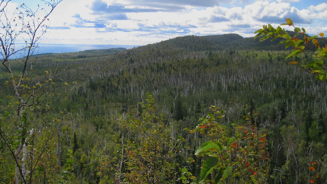
We headed out onto the trail at 9:30 am. It was quickly becoming a beautiful day, and right from the beginning, we were awarded wonderful views of cliffs, valleys, ridges, Lake Superior, and inland lakes. We crossed paths with a family on the trail with a child of about 6. Just ahead of his parents, the kid was slowly dragging himself up the steep hill that we were descending. The parents both had enormous packs, and the dad's had a stuffed giraffe peeking out of it hilariously. Although we were tired, we both thoroughly enjoyed the hike on this day. We walked along a ridge above Wolf Lake, which is a beautiful curvy lake not far from Lake Superior. We stopped to take in the view, and from where we stood, we could see both lakes if we looked just slightly to our left. This was one of our favorite spots on the trip and would be a spectacular place to live.

Wolf Lake. Lake Superior is just a little to the left.

The next two hours were spent hiking up and down the ridge, with almost continuous great views. We stopped for short breaks here and there, and just before we reached High Falls, we walked through a shady tunnel of fir trees. We heard a loud racket in the forest and thought that we might finally see some exciting wildlife, but it turned out to be a big pileated woodpecker noisily making its way through the thick trees. A spur trail led us to a long, steep staircase to the base of High Falls on the Baptism River. Once we saw this place, we decided a long lunch break was in order. Or maybe a permanent stay – it was not an easy place to leave.

High Falls

This part of the trail travels through Tettegouche State Park, and this waterfall is accessible to day visitors. Despite this, there were only two other people there with their dog until Farmer John caught up with us and decided to eat lunch there as well. The day had turned out gorgeous, and I couldn't believe how lucky we were to arrive here when the weather was good and it was not crowded with park visitors. We stayed here for an hour, and I took countless pictures now that my camera battery scare was over. Farmer John told us more of his hiking stories and showed us a few photos from his PCT trip. It was amazing to see his physical transformation. Now he was healthy and fit-looking, regularly covered 15-20 miles a day, and looked like he had never been out of shape. The photos showed a very different person, and he looked weird clean-shaven. He was pretty sure he was going to keep the beard.

After reluctantly leaving High Falls, we followed the trail across a metal suspension bridge over the river near the top of the waterfall, passed a few confusing trail signs within the state park, then headed back into the forest. The next major encounter was a section of trail referred to as “The Drain Pipe,” a steep, 150-foot crevice with rock steps. It was scary to deal with, and I was extremely thankful that it wasn't raining, hailing, snowing, or icy in any way. A sign announcing its presence is attached to a cedar with a sinister-looking tangle of roots. We stood staring at the rocky climb for a few minutes, and Craig commented that it looked like a cataclysmic event happened to make this section of trail. I attached my trek poles to my pack and hauled myself up, the whole time aware that one slip or wrong move would pitch me backward and that things would go very badly from there.

The magic bench
A few hours after leaving High Falls, we were tired and getting ready for a break. Craig mentioned that he hoped we found a good resting spot soon, and less than 30 seconds later, a bench suddenly appeared in the middle of a clearing near a trail junction. Magic! We took a break with our packs off here, and Farmer John caught up with us again. Although he hikes much longer distances than we do, he is very social and often stops to chat along the way, which is why he kept "catching up" with us (not because we were faster). We ended up hiking the rest of the day with him, and the afternoon was filled with awesome views, just as the morning had been. We climbed a dome called Mt. Trudee, which provided far-reaching views of the forest and a few small lakes. A little further on, the Bean and Bear Lakes area was our destination. There is a campsite directly on the shore of Bear Lake, which is supposed to provide space for a few tents, and we were looking forward to stopping for the day and having a relaxing night at camp without having to hide from the weather.

On the trail above Bear Lake

Unfortunately, the campsite on Bear Lake was taken, which was disappointing for a few reasons: 1) it was awesome and truly right on the shore of the beautiful lake; 2) we had to hike down a very long, steep hill to get to it, which we now had to hike back up; and 3) we were really tired at this point. Luckily, a few makeshift, overflow campsites had been created at the top of the hill just off the trail, probably because this happens a lot. A hand-written sign attached to a tree dubbed this area “The Rest Stop”. It is actually a decent place to camp; the lake below can still be seen through the trees, and there was plenty of space for Craig and I and Farmer John to set up separate camps, each with it's own fire ring. We were very excited to finally have a campfire, since we had not yet done so, mostly due to the extreme wind. We were not excited at the lack of privy (it was located near the real campsite down at the lake) or the fact that the steep hill had to be descended and climbed once again to collect water from the lake. I was glad that this extra campsite existed, however, and that we didn't have to keep going to find somewhere else. It was close to getting dark, and the cold was quickly creeping up on us along with the setting sun.

Bear Lake at sunset

We quickly set up camp, and I collected wood and started a fire while Craig revisited the lake for water and began preparations for dinner. It was nice to have a fire at last, and we stayed up for as long as we could to enjoy it. Once all of the wood had been burned we turned in. Our feet were very sore and it was another sub-freezing night, but the day's experience had been worth it. I laid awake in the dark listening to a loon calling out across Bear Lake and felt extremely happy to be right where I was, despite the cold and uncomfortably hard ground. We had just a few miles to hike the following day back to the car, and even though I looked forward to driving to a restaurant and eating everything in sight, I was sad that it was coming to an end.

Our campsite above Bear Lake

To be continued in: Day 6 – Beautiful Bear Lake, Breathtaking Bean Lake, and Bountiful Breakfast

Sunday, November 20, 2011

Superior Hiking Trail | Day Four

Section 13 to Kennedy Creek

From the ridgeline - one of many awesome views of Lake Superior and surrounding hillsides

The morning of day four was miserably cold, and as much as I wanted to pack up as quickly as possible, I could not get my fingers, limbs, or brain to cooperate beyond a zombie-like shuffle. The night before had been long, freezing, and uncomfortable. It still had not rained beyond a brief sprinkle here and there, but the wind remained relentless. My +15 down mummy bag, which is usually much warmer than necessary, had proven barely adequate. At some point during the night, I had to put on the fleece jacket that I had folded up under my pillow for extra cushion. I wore a wool hat, and my sleeping bag's hood was cinched tightly around my face, but the exposed area around my eyes and nose did not receive much relief from the cold air. We ate Pro Bars for breakfast because it was too windy and cold to consider lingering to make coffee and oatmeal. Plus, since we hadn't come across a water source at the end of the previous day, we did not want to waste our drinking water cooking a hot breakfast.

View from the rocky bald at the top of Section 13 Cliffs at 7:30 a.m.

Although we looked forward to warming up once we got going, it was cold enough that we had to start out wearing fleeces, hats, gloves, and long underwear under our clothes. We stopped for a few minutes to take photos and admire the view at the amazing 360º vantage point just down the trail. The moon stood out in the clear blue morning sky, and we were fairly sure we could see ice on the surface of a distant beaver pond. The sun shone brightly and the wind was insane. I climbed up to the highest point, where I tried to take in the moment and commit the view around me to memory before the punishing wind became too much to handle. We headed back into the woods along the same stretch of trail I had walked the day before in search of the stream that was said to be located ½ mile south of the campsite. After about 30 minutes, we came to a tiny stream, barely more than a trickle, which we estimated to be about 1 mile from Section 13. We assumed this was Sawmill Creek, the stream mentioned in the book, though we expected a little more fanfare. We stopped to filter a small supply of water here, not knowing how many of the streams we would cross that day would actually contain water due to the dry conditions. About 10 minutes after leaving this tiny stream, we reached the real Sawmill Creek, a much larger stream marked with a sign. Obviously, this stream is much further than ½ mile from Section 13 campsite – word to the wise.

The hiking was noticeably more strenuous today, with a lot of steep, rocky climbs. After a few hours, we stopped at the top of a steep ascent to ditch the long underwear. We finally saw our first view of Lake Superior at 10:30 am, which was cause for celebration. Stopping to take a few photos, I had a horrible realization: It hadn't occurred to me to protect my camera batteries from the cold of the night before, and my current battery was prematurely reading as nearly drained. I put it in an inside pocket for body heat and hoped that it would revive itself. I tried to take photos sparingly during the day's hike, but of course, the scenery was really starting to get good at this point, and for the rest of the day we were met with constant scenic views of the lake to our east and the valley to our west. Luckily, the batteries had life in them again once they spent the day warming up, and I made sure to keep them and my headlamp batteries in my sleeping bag with me overnight for the rest of the trip.

Another view from the ridgeline

We descended steeply, crossed County Road 6, then climbed back up again to the top of the ridgeline. Once at the top of the steep ridge, we looked back down into Sawmill Creek Valley and the road far below. Another sharp climb followed, which led us to the top of Sawmill Dome, another scenic viewpoint. We continued hiking along the ridgeline above Lake Superior and were awarded with many views of the lake and surrounding landscape. The views were awesome, but the weather continued to torment us. The never-ceasing wind blew in more threatening clouds, and just as we came out of tree cover onto an open stretch of trail along the side of a cliff, it began to hail. We retreated back into the trees, seeking shelter from the frozen, pea-sized bullets. The hail lasted for only five minutes, but the weather remained ominous. One minute the sky was clear and sunny, the next minute black clouds would float across the sky, bringing short bursts of rain before floating away again as if nothing had happened. Again, it never actually stormed; it was as if nature was taunting us and letting us know that it controlled us, not the other way around.


Climbing to the top of Sawmill Dome

Shortly before reaching Kennedy Creek, the SHT passes through a clearing and some land managed by a power company. As we walked through this clearing, to our left was a clear view out to Lake Superior. Though we were walking in sun, clouds hung over the lake, and we could see rain misting down over the water. There are campsites on the east and west sides of Kennedy Creek. We chose the west site, and proceeded to make up for not eating much that morning or the night before. The creek was completely dry, but Craig found a small lake nearby for water. We inhaled ramen noodles, followed by Pack-it Gourmet's banana pudding for dessert. Honestly, I do not remember whether we stopped for lunch on this day, or just ate a snack while hiking. I did not take many photos because I was attempting to conserve my frozen camera batteries, and once we set up camp, I was so cold that I did not write down many notes about the day.

Near the beginning of the climb to Sawmill Dome

Once we cleaned up after our dinner, we chose a spot for our tent nestled in the trees directly alongside the dry creek bed. If the weather had been better and the creek flowing, it might have been a nice night. The reality was not so nice. It hailed again while we were pitching our tent, the temperature had dropped further, and now that we were not moving anymore, I was getting colder by the minute. I had put on additional layers before dinner, but they were no longer helping. When the tent was set up and our food bag hung, I got in the tent and did not come out again except when I had to go to the bathroom and could not hold it any longer. It was only 5:30; I was in for a very long, cold night. I put on nearly every item of clothing I brought – including my rain gear – and didn't take any of it off when I went to sleep. This included 2 pairs of wool socks, long underwear, hiking pants, rain pants, long-sleeved wool t-shirt, long-sleeved polyester t-shirt, fleece jacket, rain jacket (with hood up), wool hat and gloves.

Kennedy Creek - dry like many other streams on this trip

I laid in my sleeping bag and attempted to read a book and maybe take a nap to pass the time. For the first time since the beginning of the trip, we suddenly had company. I heard someone calling 'hello', and looked out to see a bearded 61-year-old man walking around in camp wearing shorts and a short-sleeved t-shirt. My first reaction was extreme irritation – one because I had to get half-way out of my sleeping bag to see what was going on and I was already cold because of it, and two, because he was clearly mocking me with his fashion choices. Although I only briefly spoke to him before grumpily crawling back into my sleeping bag for the night, I learned that he had hiked 18 miles that day and that he had begun his hike back in August. He had hiked the entire 235-mile length of the SHT from south-to-north, then turned around and was in the middle of hiking it back the other way. (The total length of the SHT is 277 miles, but the 42-mile segment south of Duluth is currently day-hiking only. He was considering tackling that portion after his current round trip.) He did not have any warm clothes with him, because it was hot when he started one month earlier. At some point when he passed through a town, he was going to buy warm clothes, but the cold came out of nowhere and he hadn't gotten around to it yet. He had been through a town a few days earlier and told us about the huge forest fire raging just north of us in the Boundary Waters area. This was the source of the mysterious ash that had been in the air over the last few days, and it was also contributing to the unusual weather. By this point the fire was big news across the country and we had had no idea.

Another glimpse of Lake Superior. A freighter can be seen on the lake - click to enlarge

Our new friend's name was John (trail name: Farmer John), and we would end up learning many more interesting things about him the following day, when I was feeling more social. Until then, I would spend the coldest night of my life thus far, again getting very little sleep. What sleep I did manage was disturbed by a dream of my dog crawling up onto my chest to cuddle. The problem came when I realized that I hadn't brought my dog, so whatever was crawling on me could not be her. In my dream, I refused to open my eyes and began to reason with myself. By the feel of the paws and the weight, it must be a coyote; however, it would be impossible for a coyote to get past the tightly staked and zipped rain fly, then the zipped tent door without me waking up. Even when I'm not freezing to death and attempting to sleep on a bunch of rocks and tree roots, I'm a very light sleeper. One paw, then another, then the entire weight of a 50-lb animal was on me. It felt 100% real, and it was too much to handle anymore. I told myself that there was no way this could possibly be happening, that I had to be dreaming, and that I needed to wake up. That worked, but once I was awake I remembered how cold it was and thought death by midnight coyote attack might have been more enjoyable.


On top of the bald on Section 13. Amazing 360º view!

A check of the weather history after I returned home revealed that the overnight low had been 26º F. After the warm first 2 days (when I had actually been complaining that it was too hot and that I wanted cold weather), overnight/early morning lows for the rest of the trip were mid-20s to mid-30s. We thought we were pretty well-prepared for cold, but we hadn't anticipated nights below freezing. I thought of the couple from Kentucky that we met on the shuttle and wondered how they were holding up.


10:30 a.m. on Day 4: Our first glimpse of Lake Superior.

To be continued in
Day 5: Kennedy Creek to Bear Lake (the story of Farmer John and an awesome day all around!)

Saturday, October 29, 2011

Superior Hiking Trail | Day Three

Egge Lake to Section 13 Cliffs

Egge Lake, 6:30 a.m.

After a restless night without much sleep, I woke up for good at 6:30 a.m. and listened to loons calling on Egge Lake. A full moon hung in the sky above the lake, and it was very cold. Bundled up in fleece jackets, hats, and gloves, we made breakfast before packing up and heading back onto the trail at 9:00 for a nice, cold morning hike.

East Branch of Baptism River

Our destination was Section 13 Campsite, located at the top of the steep Section 13 Cliffs, which is a popular spot for rock climbers. Although we still did not have any views of Lake Superior, the trail was very scenic and interesting throughout the entire day. We crossed the Baptism River again and passed an old bear den which was marked with a sign. It was cold, but the sun shone through the trees, creating a beautiful green glow all around, with the occasional splash of fall color jumping out.


The green glow

We stopped for lunch at Leskinen Creek Campsite, which is spacious and could fit several tents. The temperature remained somewhat cold, the sky became overcast, and the wind picked up again as we sat on a bench by the fire ring, cooking and eating Mary Jane Farms' Chili Mac. We did not linger there long, as the weather was becoming increasingly temperamental, and we wanted to make it to the next campsite as soon as possible.


Awesome forest scene

There were many more steep climbs along this section of trail than during the previous two days, and a lot more scenery to enjoy as a reward. At one point, we climbed up a long, steep stone staircase surrounded by trees, which darkened the path and made me think of the
perilous, never-ending hidden staircase of Barad-dur. The trail skirts an enormous boulder, which was left behind by a retreating glacier at the end of the last ice age. It is a couple stories high and was a definite trail highlight.

The Glacial Erratic

We traveled across a few bog areas, and crossed a large beaver pond called Sawmill Pond on a long stretch of boardwalk. A trail register is posted at one end, and someone had recorded details in it of a bear sighting at the pond the day before. The only wildlife we would encounter that day was a grouse that scared us when we accidentally flushed it next to the trail. Just before I finished crossing the pond, it began raining. I put my camera away for safe-keeping, and missed the chance to get a picture of the beaver lodge, which eventually came into view. The rain didn't last long, but came and went several more times throughout the day, causing us to put our rain gear on, then remove it a few minutes later on more than one occasion. The sky was filled with dark, menacing-looking clouds, and the wind had continued to get stronger, leading us to believe we were in for a storm, but so far it had been just one false alarm after another.

The boardwalk crossing Sawmill Creek Bog Area

Crossing Sawmill Beaver Pond

There is no water access at Section 13 Campsite, but according to the guide book, there is a stream ½ mile north and another ½ mile south of camp. We did not want to rely entirely on these streams having water (many of the streams we had encountered so far were dry), so we stopped for a little water at a stream we crossed earlier in the day. If the streams near Section 13 were flowing, we would be able to collect more for cooking; if not, we would at least have enough to drink until finding more the following day. We eventually climbed to the top of Section 13 cliffs and reached our campsite at the top. The first of the nearby streams had been bone-dry, and by the time we reached camp, the weather had become frightening. It sprinkled off and on, a storm still threatening but holding back; however, the wind howled and was so strong that I was afraid to get close to the edge of the cliffs.

Aster along the trail near Section 13 Cliffs

We rested for only a short time before determining a good spot for our tent and quickly setting it up, staking extra guyout lines for the rainfly just in case. I had been excited about camping in this high spot with its amazing views, but my excitement began wearing off as the temperature continued to drop, and I watched the towering trees swaying in the wind all around our tent. Unfortunately, I would not be doing much exploring of the cliffs or drinking hot chocolate by a fire, which I had been fantasizing about all day.

Section 13 Campsite

It was only 4:30, and despite the weather and the day's strenuous hike, I was feeling energized and volunteered to hike to the next stream, an alleged ½ mile south. I put my winter hat and rain jacket on, grabbed one of our Platypus water containers and headed out. Almost immediately, I found myself on top of a bald where it is possible to take in a spectacular 360º view of the surrounding forest, river valley, and other cliffs. The intense wind prevented me from spending much time here, however, and I returned to the trail and my quest for water. It began raining, and the wind drove the cold drops sharply into my face until I began descending into the woods, taking cover under the trees.

Looking out from near the top of Section 13 Cliffs

The trail descends very steeply here and there was no stream in sight. I hiked on, thinking that maybe it would be just beyond the next hill. Then the next. This went on and on until I was certain I had hiked further than a half-mile. At this point, I could see far enough ahead to determine that this supposed stream was either dry or a total fabrication. Turning around, I began the steep climb northward back along the trail toward camp. By now it was extremely cold and the wind was brutal. With only a small supply of water and the unpleasant weather, we skipped cooking dinner and just ate a quick snack before hanging our food bag and retiring to the tent. By 7pm we were in for the rest of the night. I had wanted to return to the excellent vantage point just down the trail to take some photos at sunset, but the sky was so overcast at this point that there would not have been much of a view. I crossed my fingers that the morning would be better, changed into heavier wool socks, long underwear, and a long-sleeved Smartwool t-shirt, and settled in for the coldest night of sleeping I had ever experienced (until the following night).

Sawmill Beaver Pond

To be continued in Day 4: Section 13 to Kennedy Creek